On Saturday we chose to attempt one of the most popular Peak District
Looking out from near the top of Lose Hill
walks, one which takes in Lose Hill, Back Tor, Hollins Cross and, finally, Mam Tor. Much of the land through which the walk passes is now maintained by the National Trust and we were able to do the whole nine miles directly from Bailey without needing to drive anywhere. This was particularly helpful as, unsurprisingly, everywhere was busy on the first Saturday of half term week with a Bank Holiday thrown in too! This was our first walk with lots of people around, we think, ever. It was nice to feel part of 'something' and the majority of walkers exchanged smiles and hellos.
The hardest part of the whole walk was definitely the long, steep ascent
Looking up Lose Hill wondering if
turning round already would be wiser
up Lose Hill from Hope. We both needed to pause a few times to catch our breath although it was encouraging that we didn't look in any more distress than others doing the same ascent. We even overtook a group of teenagers! The uphill had started pretty much from our campsite - all our best walks start with ups - but with a gentler gradient, and then it got steeper and steeper. This photo is of the final incline, presumably paved to help against erosion, and I was considering calling the whole thing off! But, as you can see, Dave (in the white t-shirt) was already ahead of me and I wasn't going to let him beat me to the top! The views once there were outstanding and almost made the effort worthwhile. As you can see, we didn't have a perfect day so I guess we might be able to see even further without the haze. There is an engraved metal 'compass' which gives the distances to other hills and significant local places.
Compass on top of Lose Hill
The walk from Lose Hill to Back Tor was gentle by comparison. We managed to outpace to the toddler who had made up almost entirely under her own steam. The path here is unevenly rocky and sandy again. The descent from Back Tor slowed me down again. It was nowhere near as scarily scree-ey as such paths can be in Spain and I noticed that my feet didn't slide inside my North Face boots in the same way as they had in my worn-out Karrimor ones so I felt far more stable.
It's Dave again!
The Back Tor descent
I don't know why Hollins Cross is called that. There wasn't a cross at the top so maybe it is like Hope Cross and indicates an old crossroads here rather than a religious site. We were being joined my more and more walkers as we continued. Goodness only knows how busy it must get up there in July and August! Mam Tor was our final of the four hills. The name translates as Mother Hill and apparently this is due to one disintegrating edge which has fallen away to create a number of smaller hills at its base.
Mam Tor
When the light is right, we can see this view from our campsite and have been looking up here for a week, looking forward to standing on the top but I forgot to try and see Bailey from up there. I doubt I will return to rectify this! In the ground on the top, I saw what looked like a metal bangle embedded in concrete, but it was so busy I didn't take much notice. On the way down though, I saw this metal reproduction of a pot fragment also embedded in concrete so I think they must be National Trust commemorations of archaeological finds. I don't know if there are any others.
Pot fragment on Mam Tor
We passed Treak Cavern, one we haven't visited yet, on our walk to Castleton. We weren't tempted to stop but I did see this poem inscribed onto a bench seat beside the path just beyond the cavern gift shop. Thwe words are by Judy Meetham, about whom I haven't been able to find out anything, and I think the bench was installed to celebrate the fiftieth anniversary of the Peak District Ranger Service in 2004.
Bench with poem by Judy Meetham
The day trippers in Castleton made the hills feel positively secluded. We joined in the fun by queuing at a shop doing a roaring trade in Bradwell's dairy ice cream. I can recommend the Rum and Raisin flavour and Dave enjoyed his Midnight Mint. The sun had come out by now and it felt like a proper Bank Holiday weekend. Wearily, and with still an hour's walking to go, we wended our way home to Hope for a well-earned Lamb Pie dinner!
I took this final photograph on Dave's proper camera, rather than overtaxing my phone which doesn't cope well with big views. Dave is on top of Lose Hill with our path to the three remaining peaks stretching away into the distance.
Today we enjoyed the second part of our Castleton caves joint ticket by paying a visit to The Devil's Arse, also more politely known as Peak Cavern. The more interesting name apparently came about due to local folks in historical times believing that the sound of gurgling water that sometimes heard from within the cave was actually the Devil himself farting. Although no water gurgled today, our guide did imitate the sound and I could understand why superstitious minds made the connection! The renaming was a hasty decision for Queen Victoria's first visit, a question of decorum!
The mouth of Peak Cavern is massive, so massive in fact that I couldn't get far enough back to capture its expanse in a photograph so you've got the dramatic cliffs overshadowing the path instead. Within the entrance cavern, we were treated to a demonstration of ropemaking - from fragile flax to sturdy rope - which we both found fascinating. Parts of Hailsham are named for the ropemaking industry there, but I had never thought through its practicalities before. I now understand just what that statue outside Hailsham Tesco is doing! Troglodytes lived and worked in Peak Cavern as ropemakers from the 1600s until 1915, amazingly, and we saw what I presume is a replica of one of their tiny dwellings
Peak Cavern does have some low overhangs, but is far less claustrophobic than Speedwell Cavern and is completely walkable - no boat rides here. We were shown rock formations including flowstones and unusually dark coloured little stalactites, the result of water trickling through volcanic rock above. Another change for Queen Victoria, this time for her second visit, was the blasting through of a short bypass tunnel at one point, high enough for her to walk through. Previously visitors had lain individually in a 'boat' that looked suspiciously like an unlidded coffin and been shoved through a very small aperture along a short stream. It looked horrifying so I was glad of the manmade alternative. Most of the Cavern is still natural though.
Approaching Peak Cavern through Castleton
Speedwell Cavern and Peak Cavern could easily both be visited in a single day, although it is possible to book a joint ticket that lasts six months. This is what we did, taking advantage of the early bird discount which didn't actually require us to get up especially early. Booking is advised for Speedwell and we got lucky with Peak Cavern today as there were only six people on our tour, but a whole school party arriving as we left! Do allow time to appreciate the pretty walk to Peak Cavern. From the car park, we walked along narrow streets between extremely cute little cottages and alongside a small river with arched stone bridges. All very picturesque! There were even Shetland ponies in a field (with the obligatory sheep).
On a different note, an urgent 38 Degrees appeal for action:
Our bees are in danger again. Toxic chemical companies are trying to get
their banned pesticides back on UK fields. On Tuesday an application was submitted to the government asking them to lift the ban on bee-killing chemicals for some crops planted this autumn. A huge petition will make it clear to the environment minister, Elizabeth Truss, that she still needs to protect our bees, not the toxic profits of bee-killing chemical companies. Please sign this 38 Degrees petition.
Dave planned us a great walk for yesterday's glorious sunshine. Starting
Sunken road
from our campsite, we started off with a gentle uphill along the single track road. The road is probably very old as it has now sunk several feet from the surrounding fields. Tree roots of several species can be seen all through the banks and there are bluebells and cow parsley flowering too. We thought the road part of the walk would be dull, but it was one of the highlights! There was practically no motorised traffic, just a few cyclists and a couple of women on horses. I liked how rivulets of water frequently came tumbling down the mossy banks from the ground above and wonder if they are from springs that flow all year round, or if they will dry up when summer comes?
We followed footpaths signposted towards Yorkshire Bridge and joined
the Thornhill Trail which is a traffic-free walking/cycling route alongside Ladybower Reservoir. The Trail is popular and was busy compared to the rest of our walk. I liked this (pictured) sculpture but am not sure what it is commemorating. I am not sure if the woodland is big enough to be forest, but it was wonderful to be walking with a great expanse of water one side, and trees as far as we could see up the hill the other side. Building began on the reservoir in 1935 and apparently it took eight years to complete and then another two years to fill. The bridge across is especially elegant and the reservoir has two huge stepped plugholes which are overflows to be used in times of heavy rain. I am not sure if the Ladybower dam was one used for training by the Dambusters squadron in the Second World War but it looked similar to those in the film! The even trail surface makes for fast walking so we actually extended our planned walk and continued to the far end of the reservoir where we ate our picnic lunch on a grassy bank by a much smaller metal bridge. The spot had been recently vacated by a couple of pairs of Canada geese with their goslings.
Suitably refreshed and refuelled, our footpath then took a steep uphill course for a hundred metres or so, completely changing our environment again. Now we climbed through dense pine wood which was actually much darker and eerier than the photograph suggests.
Our footsteps were completely muffled by a thick carpet of dropped pine needles and these needles coloured everything pale brown except for where vivid green moss grew on exposed rocks. The contrast resulted in an otherworldly effect and, at first sight, the rocks did appear to have been painted!
Gasping a bit at the top of the hill, we were greeted with the sight of Hope Cross - which isn't actually a cross shape, but marks a crossroads. The ancient waymarker has a different town name on each face - Hope, Glossop, Edale and Shefield (sic). The pillar is dated 1737, but the marker is believed to have stood here since at least medieval times and indicates the old packhorse routes. We took the Roman Road back in the direction of Hope. It's not quite dead straight but nicely level and wound around Win Hill giving us gorgeous views across the valley. The goods train from the cement works looked like a toy set from this height! I'm not used to seeing long goods trains at all. I don't think there were any on the line through Polegate - I certainly never saw any in the hours I spent waiting at Polegate level crossing. However, the line here passes close to our campsite and it seems there are almost as many goods trains as passenger trains.
Again, on this walk, I was glad of my North Face boots which didn't allow a single drop of water to get to my feet! I am considering buying another pair of walking trousers though. My Berghaus ones are ok, but are getting a bit thin in places and there's a small hole in the back, ripped when falling on scree in Spain. Hathersage, nearby, has a branch of Go Outdoors and I like the look of these Craghoppers trousers. They can convert into shorts too which I always find very useful. Perhaps I should wait until we have walked more first though. We have both put on some weight over the past couple of months and there is No Way I am buying a size 18!
This morning we went on a journey of a different kind - boat trip underground at Speedwell Cavern just outside Castleton. A former leadmine which was first worked in 1771, it is now a tourist attraction and quite a different experience to the Vall d'Uixo in Spain. For a start, we were issued with hard hats here, and there wasn't any gaudy lighting! I didn't get vertigo, but was a little claustrophobic at times. Our guide-boatman gave an interesting talk and both Dave and I are sure we would have been hopeless lead miners. I enjoyed the visit, but was glad to get back to daylight again. We did get a good deal on the tickets: by ordering advance joint tickets online yesterday afternoon (access to a printer needed) and choosing the earlybird offer, we got the Speedwell Cavern boat trip and a visit to Peak Cavern at-any-time-in-the-next-six-months for £24.20 for us both.
And this evening, we have another treat lined up. We are going to the NTlive broadcast of Man And Superman which is being screened by Tideswell Cinema at The George Inn in Tideswell.
Hope, where we are currently camped, is only a couple of miles from
neighbouring Castleton which was recommended to us as a beautiful village by another caravanner on our Lincoln campsite. Braving sporadic drizzle and winds that were a bit blowy, we donned waterproofs this afternoon and set out for a looksee.
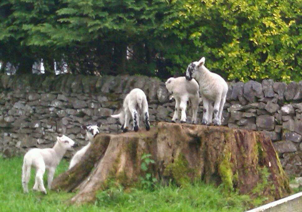
We had already walked into Hope this morning for a spot of shopping and found the greengrocer, Spar, and the farm shop. There's a post office and a deli too and we will definitely be visiting the farm shop again! This afternoon we turned left by the church, out into sheep fields and along by Peakshole Water, a pretty and winding stream. The well-worn footpath followed the stream initially before heading away through more sheep fields. There are adorable lambs everywhere at the moment so I apologise for including another sheep photo - there will probably be one in each post for a while! Here, just outside Castleton, five lambs were trying to all stand on a tree stump that was only big enough for four so they kept tumbling off in various ungainly leaps.
Room for one more?
Castleton is indeed pretty and has an inordinate number of pubs. I guess this is a sign of how busy the area gets in the high season. We enjoyed a wander around and spent some time in their Visitor Centre which has an informative little museum alongside the usual display of regional products, leaflets and Ordnance Survey maps. We learned about local geology and saw a thousand-year-old stone representation of the goddess Brigantia. Outside the centre were several concrete squares indented with the
Judy Leden stone outside
Castleton Visitor Centre
name and footprint of a famous person linked to the area. I'm not sure the footprints were genuine as a couple dated back hundreds of years, but I did discover today's inspirational woman among them: Judy Leden MBE is a hang glider and paraglider pilot who has won three world championships and also crossed the English Channel in a hang glider!
After the (obligatory, surely?) purchase of what later turned out to be lovely Lemon Drizzle Cake for me and a huge Malteser Slice for Dave - I forget the name, but that's another shop we will return to - we started homewards on a different path around the other side of the village. Stone step stiles are a feature here, as well as many little wooden gates. These steps were actually on the edge of Eyam Moor, photographed on Monday's walk but we went over others today.
Stone step stile on Eyam Moor
The walk back was dry with warm sunshine trying to get the better of blustery winds. I've got a few more photographs to post here ending with how our lovely Farfield Farm CL looked on our return this afternoon. It doesn't get much better than this!
Apple blossom buds
Oak apples - there's a local Oak Apple Festival day